2 hours
Classic loop
- 1Walk the downtown river loop
- 2Cross several bridge levels
- 3Finish near La Villita or Alamo Plaza

South Texas Plains · Lakes & Rivers
San Antonio's 15-mile river corridor links the famous below-street downtown promenade with the Museum Reach, Pearl and the Mission Reach, combining cypress-shaded walks, restaurants, public art, river cruises and some of the city's most important historic places.
Photography: Yinan Chen · Public domain · Wikimedia Commons
Plan the visit
The place
The San Antonio River Walk is best understood as a long urban corridor, not a single downtown attraction. The postcard section below street level is the part most visitors know first: cypress trees, limestone walls, arched bridges, restaurants and passenger boats winding through the center of the city. But that downtown loop is only one piece of a roughly 15-mile system that continues north through Museum Reach and south through Mission Reach.
Downtown is the right starting point for a first visit because several of San Antonio's major landmarks sit within an easy walk of the river. The Alamo is only a few blocks away, while La Villita, Main Plaza, historic hotels, theaters, restaurants and museums create a dense itinerary that does not require a car once you are in the center. A river cruise can provide a quick orientation, but walking the paths at your own pace reveals bridges, stairways, landscaping and architecture that are easy to miss from the water.
North of downtown, Museum Reach changes the feel of the River Walk. The river corridor becomes a broader cultural trail with public art, landscaped paths and connections toward Pearl. The San Antonio River Authority notes that this reach includes about three miles of paved trail and a lock-and-dam system that lets passenger barges travel between downtown and the northern reach. It is a useful choice for visitors who want a longer walk with fewer restaurant crowds and more room to focus on the river itself.
South of downtown, Mission Reach shifts again. Here the River Walk becomes a recreation and heritage corridor tied to the San Antonio Missions National Historical Park landscape. Walking and biking paths follow restored river habitat toward the missions, making it possible to connect the city's famous downtown tourism district with a much older story of settlement, irrigation, Indigenous communities and Spanish colonial life. This section is especially valuable for travelers who want to see how the Alamo fits into a larger network of missions rather than treating it as an isolated site.
Timing changes the experience. Early mornings are quieter and cooler, especially in summer, while evenings bring reflections, restaurant activity and one of downtown San Antonio's best-known nighttime scenes. Weekends, conventions, festivals and the holiday-light season can make the central loop much busier. Because the Downtown and Museum Reach sections remain open around the clock but Mission Reach is daylight-only, a practical full-day plan is to use daylight for the southern trail and missions, then return downtown after dark.
The River Walk is also a strong trip-planning spine. Pair it with The Alamo for an easy first half-day, extend north toward Pearl for food and culture, or head south toward San Antonio Missions National Historical Park for a history-heavy day. TexasDefined's Bexar County guide adds the wider geography: the river is not just a visitor attraction but the waterway around which San Antonio's mission system, civic center and later public spaces developed.
The details
Tours & bookable experiences
TexasDefined handles the destination planning. Viator can be useful for guided tours, tickets and organized activities near San Antonio. Availability changes, so the booking link checks current inventory rather than promising a specific product.
Recent San Antonio inventory signals: History & landmarks · Food & barbecue · Ghost tours & nightlife. Reviewed ; exact products and availability can change.
Affiliate disclosure: TexasDefined may earn a commission from qualifying Viator bookings, at no additional cost to you.
Quick answer
Field notes
Conditions, closures, fees and availability can change. Use these notes to plan, then confirm the latest details with the official site before making the drive.
TexasDefined authority guide
Operational facts are tied to official sources and a recorded review date. Supporting agency, institutional, conservation, science and historic-designation sources add context where useful. TexasDefined's planning assessment is editorial judgment—not a paid rating or a claim of an unrecorded personal visit.
Verified visitor information
Reviewed August 17, 2026
Editorial assessment
Why it matters to Texas
The River Walk is both a visitor icon and a piece of civic infrastructure that ties downtown, Museum Reach, Pearl and the mission corridor to the San Antonio River. Its value is in seeing how one waterway links tourism, public space, history, art and restored habitat.
Use the time you have
2 hours
Half day
Full day
Before you go
What's in the area
Because the River Walk passes through several distinct parts of San Antonio, the best nearby choices depend on which reach you are using. Downtown favors landmark-hopping on foot, Museum Reach favors museums and Pearl, and Mission Reach is the gateway to the city's Spanish colonial mission corridor.
Nearby
Easy additions that fit naturally around the main stop.
About a 5-minute walk from the downtown loop
The city's signature historic landmark is close enough to combine with the River Walk in the same morning or afternoon without moving the car.
Directly beside the downtown River Walk
Historic buildings, galleries, shops and small courtyards create one of the easiest above-river detours from the central loop.
On Museum Reach
A major art museum housed in the former Lone Star Brewery complex, directly accessible from the northern river trail.
A short walk from the downtown loop
Public parks and play spaces around the former World's Fair grounds add green space and family-friendly downtime near the convention-center end of the river.
Eat nearby
Dining districts and food areas worth building into the same outing.
On the river
The central loop has the greatest concentration of riverside restaurants and patios and is the simplest choice when convenience matters most.
On Museum Reach, about 2 miles north of Downtown
One of San Antonio's strongest food districts, with restaurants, cafes, markets and culinary businesses concentrated around the former brewery complex.
Just south of the downtown loop
Neighborhood restaurants, bars, cafes and galleries make this a good alternative to the most tourist-heavy blocks along the central river.
Stay nearby
The most practical lodging areas for minimizing driving and maximizing time on the ground.
Direct access
The most convenient base for first-time visitors who want to walk to the Alamo, river cruises, downtown dining and major central attractions.
About 5–10 minutes on foot
A practical alternative for travelers prioritizing The Alamo, Hemisfair and the eastern side of the downtown loop.
About 2 miles north
Best for travelers who want a quieter riverfront base with destination dining and direct access to the northern walking trail.
Explore more
Nearby parts of the city that add character, shopping, history or nightlife.
Central River Walk
The historic visitor core combines the river, Alamo Plaza, Main Plaza, theaters, civic landmarks and La Villita within a compact walking area.
South of Downtown
Historic homes, galleries, local restaurants and neighborhood streets create a more residential counterpoint to the downtown river loop.
North along Museum Reach
Historic industrial architecture, public spaces, food and shopping make the northern river extension feel like a separate destination rather than merely a trail continuation.
With kids
Good nearby additions when the itinerary includes younger travelers.
Short walk from the downtown River Walk
A free public play area with splash, climbing and adaptive play features that gives families an easy break from sightseeing.
About 3 miles north of Downtown
A hands-on children's museum that pairs well with Museum Reach, Pearl or a north-side family itinerary.
About 3–4 miles north
A strong family combination of Texas natural history, science exhibits and outdoor park space beyond the river corridor.
Go farther
Places that justify extending the visit beyond the immediate area.
Mission Reach, roughly 3–9 miles south of Downtown
The river trail links toward Concepción, San José, San Juan and Espada, letting travelers turn the River Walk into a much deeper history-and-outdoors itinerary.
About 1 mile west of the downtown loop
A three-block Mexican market district with food, shopping and festivals that is close enough for the same day but distinct from the riverfront experience.
About 3 miles north
A worthwhile green-space extension that works naturally with the Witte Museum or a longer north-side outing beyond Museum Reach.
Build the trip
Nearby places, worthwhile detours and combinations for adding water, history, outdoors or a full weekend around this destination.
Close enough for the same trip
Places ordered by straight-line distance when reliable coordinates are available.
San Antonio · Bexar County · South Texas Plains
A downtown San Antonio aquarium at the Shops at Rivercenter with an ocean tunnel, sharks, rescued sea turtles, stingrays, seahorses, jellyfish and a touchpool.
Approx. 1 miles away
San Antonio · Bexar County · South Texas Plains
San Antonio's best-known historic landmark: the former Mission San Antonio de Valero, where more than three centuries of mission, military, revolutionary and preservation history converge in the heart of downtown.
Approx. 1 miles away
San Antonio · Bexar County · South Texas Plains
A downtown San Antonio museum and historic saloon whose horn-and-antler collection grew from Albert Friedrich's 1881 business and now shares the attraction with the Texas Ranger Museum.
Approx. 1 miles away
San Antonio · Bexar County · South Texas Plains
The Spanish Governor's Palace is an eighteenth-century Spanish Colonial residence in downtown San Antonio and the last visible architectural trace of the Presidio San Antonio de Béxar complex.
Approx. 1 miles away
San Antonio · Bexar County · South Texas Plains
Artpace is a free contemporary art center in downtown San Antonio built around an internationally recognized artist-in-residence program, with rotating exhibitions of work created by Texas, national and international artists.
Approx. 1 miles away
San Antonio · Bexar County · South Texas Plains
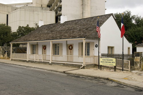
The restored home and property interpret the life of José Antonio Navarro, a Tejano statesman, signer of the Texas Declaration of Independence and influential early Texas leader. Casa Navarro adds an indispensable Tejano perspective to a San Antonio history itinerary that can otherwise lean too heavily on military sites alone.
Approx. 1 miles away
Around San Antonio
Other destinations connected to San Antonio.
San Antonio · Bexar County · South Texas Plains
An interactive northwest San Antonio attraction combining sharks, stingrays and marine life with animal encounters involving birds, reptiles and mammals.
Approx. 9 miles away
San Antonio · Bexar County · South Texas Plains
San Antonio Zoo includes the historic Friedrich Aquarium, an operating 1948 aquarium with both freshwater and saltwater animals inside the larger Brackenridge Park zoo.
Approx. 3 miles away
San Antonio · Bexar County · South Texas Plains
Four Spanish colonial mission communities south of downtown San Antonio—Concepción, San José, San Juan and Espada—preserved along the San Antonio River as living parish, architectural and cultural landscapes connected to the city's UNESCO World Heritage story.
Approx. 4 miles away
San Antonio · Comal County
A major Hill Country cave attraction north-east of San Antonio where guided routes descend through enormous limestone rooms, stalactites, stalagmites and flowstone, with multiple cavern experiences and above-ground family attractions surrounding the natural limestone bridge that gave the site its name.
Approx. 20 miles away
San Antonio · Comal County
A 500-acre drive-through safari beside Natural Bridge Caverns where visitors travel in their own enclosed vehicles among more than 500 animals from dozens of species, then continue through walkable animal areas and optional guided safari experiences.
Approx. 21 miles away
San Antonio · Bexar County · South Texas Plains
A walkable San Antonio historic district south of downtown, known for ornate nineteenth-century houses, river access and one of the city's strongest concentrations of preserved residential architecture.
Approx. 1 miles away
Build a better day
Nearby parks, water, towns, history and outdoor places that complement this destination.
San Antonio · Bexar County · South Texas Plains
A major San Antonio living museum combining conservatories, Texas-native landscapes, display gardens, family spaces and horticultural education at a single garden campus east of downtown.
Approx. 3 miles away
Castroville · Medina County
Castroville is a Medina River town west of San Antonio where Alsatian settlement history, preserved nineteenth-century architecture, a large historic district, Landmark Inn and riverfront parks create one of Texas's most distinctive European-heritage small-town visits.
Approx. 24 miles away
New Braunfels · Comal County
A German-Texan Hill Country city built around the Comal and Guadalupe rivers, with tubing, historic neighborhoods, Gruene and strong access to Canyon Lake.
Approx. 29 miles away
Bandera · Bandera County
A Medina River Hill Country town where cowboy heritage meets public river swimming, tubing and paddling, with music, horseback riding and access to rugged country west of San Antonio.
Approx. 41 miles away
Add some water
Lakes, rivers, springs and coastal places that can fit into the same trip.
Spring Branch · Comal County
Four miles of Guadalupe River frontage between San Antonio and the Hill Country, pairing cypress-lined swimming and paddling water with trails, camping and access to the protected Honey Creek landscape.
Approx. 30 miles away
Wimberley
A spring-fed swimming area on Cypress Creek inside Wimberley's Blue Hole Regional Park, shaded by mature cypress trees and managed through a seasonal reservation system that protects the experience from uncontrolled crowding.
Approx. 47 miles away
Blanco · Blanco County
A small Hill Country park wrapped around a mile of the Blanco River, with limestone dams, swimming, fishing, paddling and shaded picnic areas within walking distance of downtown Blanco.
Approx. 47 miles away
Wimberley · Hays County
A deep artesian spring and karst opening near Wimberley that forms the headwaters of Cypress Creek, protected within a Hays County natural area with trails and tightly managed water access.
Approx. 47 miles away
Add some Texas context
Historic sites, small towns and road-trip stops that add context to the route.
San Antonio · Bexar County · South Texas Plains
Villa Finale is a richly furnished historic house museum in San Antonio's King William Historic District, preserving preservationist Walter Nold Mathis's home, decorative-arts collection, musical instruments and landscaped gardens.
Approx. 1 miles away
Keep the day outside
Parks, caverns and outdoor destinations that pair naturally with this stop.
Gonzales · Gonzales County
A small, lush park near Gonzales where dwarf palmettos, swampy lowlands, the San Marcos River and a CCC-built landscape create scenery that feels unexpectedly subtropical for Central Texas.
Approx. 55 miles away
Lockhart · Caldwell County
A small Central Texas state park beside Clear Fork Creek, notable for wooded trails, a historic CCC-built recreation landscape and the only golf course in the Texas State Park system.
Approx. 56 miles away
Make a weekend of it
A mix of towns, food, history, parks and water that can turn one stop into a fuller itinerary.
San Antonio · Bexar County · South Texas Plains
San Antonio Museum of Art occupies the historic Lone Star Brewery complex on the Museum Reach of the River Walk, with global collections spanning ancient Mediterranean cultures, Asian art, Latin American art, European painting and contemporary work.
Approx. 1 miles away
More like this
Similar destinations, favoring the same region and the shortest available distance.
Johnson City · Blanco County
Thirty miles west of Austin, the Pedernales River pours across broad shelves of Hill Country limestone, creating a dramatic falls area plus separate places for swimming, hiking, camping and river access.
Approx. 63 miles away
Austin · Travis County
An Austin state park where Onion Creek drops over broad limestone ledges at Upper and Lower Falls, with swimming holes, trails, camping and reminders of Central Texas history only minutes from the city.
Approx. 70 miles away
Junction · Kimble County
A clear-river Hill Country park near Junction where swimming, tubing, paddling, turkey habitat, pecan bottomlands and miles of trails come together along the spring-fed South Llano River.
Approx. 106 miles away
Del Rio · Val Verde County
A remote, exceptionally clear spring-fed river natural area in Southwest Texas with two reservation-only units—Del Norte and Dan A. Hughes—protecting rugged limestone canyon country and primitive backcountry access.
Approx. 154 miles away
Lumberton · Hardin County
A quiet Big Thicket-area park near Lumberton where Village Creek winds through bottomland hardwoods and cypress, offering paddling, fishing, camping and shaded trails in humid Southeast Texas forest.
Approx. 264 miles away
Keep exploring the region
Additional places from the same Texas region.
South Padre Island · Cameron County · South Texas Plains
South Padre Island’s sea-turtle rescue and education center lets visitors learn about rehabilitation, resident turtles and Gulf conservation beside the Laguna Madre.
Approx. 241 miles away
Corpus Christi · Nueces County · South Texas Plains
A North Padre Island Gulf beach at the end of Whitecap Boulevard with both pedestrian-only shoreline and vehicle-access areas near the Corpus Christi beach corridor.
Approx. 148 miles away
Corpus Christi · Nueces County · South Texas Plains
The vehicle-free beach beside Malaquite Visitor Center in Padre Island National Seashore, offering a quieter developed access point with parking, restrooms and showers.
Approx. 155 miles away
Corpus Christi · Nueces County · South Texas Plains
The long undeveloped South Beach and down-island Gulf shoreline of Padre Island National Seashore, where remote beach driving, primitive camping and exceptional barrier-island solitude replace developed amenities.
Approx. 156 miles away
Corpus Christi · Kleberg County · South Texas Plains
A remote primitive camping and small-boat access area on the Laguna Madre side of Padre Island National Seashore, reached from South Beach by a high-clearance four-wheel-drive route.
Approx. 167 miles away
South Padre Island · Cameron County · South Texas Plains
The developed resort-city Gulf shoreline of South Padre Island, connected by city and county beach accesses and extending north toward drive-on county beach areas.
Approx. 243 miles away
Texas Explained
Go beyond the destination with the systems, landscapes and history that explain why this part of Texas looks and works the way it does.
Continue exploring
Read next
Lakes & Rivers
Deep in the Piney Woods, an old sandstone quarry filled with spring-fed water and became one of East Texas's strangest blue-green landmarks. Its railroad history, geology and legends are remarkable—but the Blue Hole is private property, not a public swimming destination.
September 7, 2026 · About 8 minutes
Lakes & Rivers
Toledo Bend stretches along the Sabine River on the Texas-Louisiana line. Its huge surface area, shared ownership and combined water-and-power role make it unlike any reservoir operated wholly inside Texas.
August 16, 2026 · About 9 minutes
Lakes & Rivers
Possum Kingdom Lake pairs a dramatic North Texas landscape with serious water infrastructure. Morris Sheppard Dam supports municipal and industrial supply, irrigation, flood control, recreation and power generation on the Brazos River.
August 16, 2026 · About 9 minutes
.jpg%3Fwidth%3D1600)

.jpg%3Fwidth%3D1600)




.jpg%3Fwidth%3D1600)
.jpg%3Fwidth%3D1600)

.jpg%3Fwidth%3D1600)
.jpg%3Fwidth%3D1600)