Texas Explained
Toledo Bend Explained: Texas' Largest Reservoir and a Two-State Water Project
Toledo Bend stretches along the Sabine River on the Texas-Louisiana line. Its huge surface area, shared ownership and combined water-and-power role make it unlike any reservoir operated wholly inside Texas.
Toledo Bend is difficult to understand as a normal Texas lake because it is not a Texas-only project. The Sabine River forms part of the boundary with Louisiana, and the reservoir is owned through the river authorities of both states. Water, electricity and shoreline all cross the state line.
The largest reservoir in Texas by surface area
TWDB identifies Toledo Bend as the largest reservoir in Texas and describes a conservation surface area of more than 181,000 acres. Scale is one reason the reservoir feels different from most Texas lakes: it stretches for well over one hundred river miles along the Sabine system.
A two-state project without federal construction funding
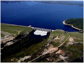
Construction began in 1964, impoundment began in 1966 and the dam was completed in 1969. TWDB notes that Texas and Louisiana shared the project cost without federal government assistance. The reservoir remains jointly owned through the Sabine River authorities of the two states.
Water and electricity are both shared
The project conserves water for municipal, industrial, agricultural and recreational purposes and includes hydroelectric generation. TWDB notes that Texas and Louisiana share both water and electricity. That shared-benefit structure makes Toledo Bend a useful example of interstate resource infrastructure.
The Sabine is the system underneath the lake
The reservoir is formed by damming the Sabine River, so its enormous lake surface is still part of a river basin. Inflow, storage and releases belong to the same watershed that continues downstream toward the Gulf.
Why size comparisons need context
Reservoirs can be ranked by surface area, conservation storage or total storage, and those rankings do not always produce the same order. TWDB calls Toledo Bend the largest reservoir in Texas and also notes its standing by total storage. The lesson is to ask which measurement a 'largest lake' claim is using.
What Toledo Bend teaches
- A reservoir can be shared infrastructure between two states rather than owned by one Texas authority.
- Surface-area rankings and storage-capacity rankings measure different things.
- Water supply, agriculture, industry, recreation and hydropower can all share one reservoir.
- Interstate river boundaries create governance questions that do not exist on wholly internal basins.
- Even an enormous lake remains part of a flowing river system.
Texas water at interstate scale
Toledo Bend expands the Texas water map beyond the state line. It shows that a reservoir can be a landscape, a power project, a water-supply asset and a two-state agreement at the same time. That makes it one of the clearest examples of how infrastructure can turn a river boundary into a shared resource.
Image credit: Texas Water Development Board reservoir record
Primary source: Texas Water Development Board ↗
Filed under
- Toledo Bend Reservoir
- Sabine River
- Texas Louisiana
- Texas reservoirs
- hydropower
- Texas water
From the magazine
More stories to read next
Lakes & Rivers
Possum Kingdom Lake Explained: An Early Brazos River Multipurpose Reservoir
August 16, 2026 · About 9 minutes
Lakes & Rivers
Lake Whitney Explained: A Brazos River Reservoir Built for Multiple Jobs
August 16, 2026 · About 9 minutes
Lakes & Rivers
Lake Travis Explained: Austin's Flood-Control and Water-Storage Reservoir
August 16, 2026 · About 9 minutes